Floods (Causes, Characteristics and Consequences)
POSSIBLE CAUSES OF FLOODS
Short-term Causes
(A) Monsoon downpour: An increased amount of precipitation can cause flooding.
(B) Synchronization of Flood Peaks: The synchronization of flood peaks for the major three rivers took place within a two week time period, causing a sudden increase in water level in virtually all areas of the country.
Long-term Causes
(A) Local Relative Sea Level Rise: Backwater effect further inland. The rate of local relative sea level rise is 7 mm/year around the coastal areas of Bangladesh.
(B) Inadequate Sediment Accumulation: The average sediment accumulation rate for the last few hundred years in the coastal areas of Bangladesh is 5-6 mm/year, which is not enough to keep pace
with the rising sea level.
(C) Subsidence and Compaction of Sediments: Subsidence along with compaction reduces land elevation with respect to the rising sea level.
(D) Riverbed Aggradation: Recent increase in riverbed levels must have contributed to the increased flooding propensity in Bangladesh.
(E) Deforestation in the Upstream Region: Deforestation of steep slopes is assumed to lead to accelerated soil erosion and landslides during monsoon precipitations.
(F) Damming of Rivers: Damming of a river reduces the velocity of water flow downstream from the dam.
(G) Soil Erosion due to Tilling: Surface run-off can easily wash away the topsoil from cultivated land. This surface erosion reduces land elevation, which in turn increases flood intensity in an area.
(H) Excessive Development: Rapid population growth creates extra pressure on the land of already overcrowded Bangladesh. For example, in a city that is totally served by storm drains and where 60% of the land surface is covered by roads and buildings, floods are almost six times more numerous than before urbanization .
(I) Seismic (Earthquake) and Neotectonic Activities: Bangladesh lies on the Indian lithospheric plate, which is pushing against the Asian plate, causing growth of the Himalayas and occasional earthquakes in the region. Earthquakes cause movement of the land, and this can change the topography of the region and alter river courses.
(J) Greenhouse Effect: The greenhouse effect will also increase the amount of rainfall and storminess, which will further aggravate the flood problem.
FLOODING CHARACTERISTICS
Flooding characteristics The Ganges, Brahmaputra and Meghna are mighty rivers with markedly seasonal flows (Table I). The average peak flow of the combined rivers in the lower Meghna is about 2.5 times that in the Mississippi river. The Brahmaputra and the Meghna begin to rise in March-April as a result of snow-melt in the Himalayas and pre-monsoon rainfall in Assam and the north-east of Bangladesh. The Ganges starts to rise later, in May, since its catchment is mainly in relatively drier areas where the rains start later. All three rivers rise rapidly in June-July with the onset of the monsoon rains proper, the Brahmaputra normally reaches its peak level in July-August and the Ganges about a month later, in August-September. Occasionally, however, the Brahmaputra peaks in late August or September, coinciding with the Ganges peak; and high Ganges floods sometimes extend into October. The Meghna follows a similar pattern to the Brahmaputra, but high levels often extend into September because of backing up of water above the confluence with the Ganges. All the rivers generally fall rapidly from September through to November, then more slowly in the dry season. However, water levels on adjoining floodplains fall more slowly because of low gradients and congested drainage, and substantial depression areas stay sub-merged until December-January, some throughout the dry season.
Types of flooding
Bangladesh generally experiences four
types of flood and those are as follows:
i) Flash Flood
ii) Rain Water Flood
iii) River Flood
iv) Flood due Cyclonic Storm Surges
1. Flash Flood
Result from exceptionally heavy rain-fall occurring over neighbouring hills and mountains. Flash floods do not necessarily damage crops or property. Where and when damage occurs, it is mainly due to rapidly flowing water (especially when flood embankments are breached) or to submergence of crops in depression sites for more than a few days. This type of flood occurs mostly in some northern most area, north-central part, northeastern part and southeastern part of the country.
2. Rain Water Flood
Are caused by heavy rainfall within Bangladesh. They are characteristic of meander floodplains, major floodplain basins and old estuarine floodplain land. flooding of 'normal' depths and timing does not damage adapted crops or property. This kind of flood generally occurs in the moribund Gangetic deltas in the south-western part of the country where most of natural drainage systems are being deteriorated due to fall in up-land inflow from the main river Ganges. It also occurs in the flood plains where natural drainage systems have been disturbed due to human interferences mainly due construction of unplanned rural roads and illegal occupation of river courses.
3. River Flood
Result from snow-melt in the high Himalayas plus heavy monsoon rainfall over the Himalayas, the Assam and Tripura Hills, the adjoining floodplains and the northern part of the central Indian plateau. They particularly affect active river floodplains. River flood is a most common phenomenon in the country from time immemorial.
4. Flood due Cyclonic Storm Surges
This kind of flood mostly occurs along the coastal areas of Bangladesh which has a coast line of about 800 km along the northern part of Bay of Bengal. Storm surges generated due to any cyclonic storm is comparatively high compared to the same kind of storm in other parts of the world.
INCIDENCE OF EXTREME EVENTS AND CAUSE
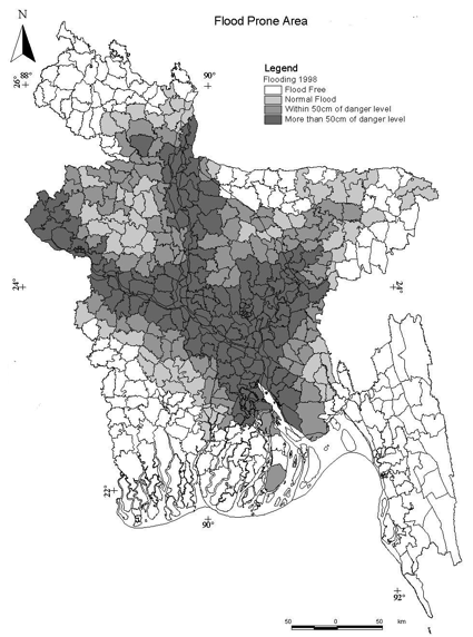
It was observed that extreme flood events occurred due to excessive rainfall in the catchments. When WLs in the three major rivers systems rises simultaneously and crosses the danger marks extreme flood situation usually occurs all over the country. This was observed during the three flood events occurred in 1987, 1988 and 1998. Water Levels crossing the danger marks starts occurring from mid-July and continue till mid-September. Inundated area during 1987, 1988 and 1998 are 66%, 68% and 70% respectively. Duration of the extreme flood events usually extends from 15 days to 45 days, the longest one occurred during 1998.
A picture of water level hydrographs of three major rivers at selected points e.g. Ganges at Hardinge Bridge, Brahmaputra at Bahadurabad and Meghna at Bhairab Bazar are presented in fig. 9, fig. 10 and fig. 11 respectively. A picture of cumulative rainfall hyetographs for June, July, August and September at selected stations within the catchments of these three major river systems for 1987, 1988, 1998 are presented in figs. 12, 13 & 14. Sometimes, Individual River may also experiences extreme flood events due to excessive rainfall in the respective river catchments independently.
Historical Flood Extents in Bangladesh

Consequences of Floods in Bangladesh
1988
Affected people: 30,000,000
Deaths: 3.000
Livestock killed: 200,000
Economic Cost: 1,800,000,000
Agriculture losts: Crops destruction
Sickness: Diarrhea (47% of deaths), respiratory disease (13% of deaths),respiratory tract infections (7% of deaths), Accidental deaths (9,7%) – most of them caused by drowning.

1998
People affected: 30 million
Deaths: 1070
Causes of death: drowning, health problems, lack of access to medical care
Sickness: Cholera, Diarrhea
Costs: 1 billion
Other consequences: crops destruction, export industries suffered 20% decrease in production, 400 clothing factories forced to close, destruction of roads and railways.
è Rural areas:
The most vulnerable areas are the low flat areas made up of deposited silt and called the "char" areas. These areas are inhabited by very poor subsistence farmers who struggle to survive in normal years. As the flood waters rose most families tried to stay in their homes and simply raised their beds and furniture to be able to live above the water. When the water reached roof level they would move to higher ground but within easy reach of their homes. In many cases their animals would drown as these areas of high ground were barely big enough to hold the people. The floods brought a considerable health risk from water borne diseases as the wells were submerged making the water unsafe. As a result diseases such as cholera and diarrhoea spread widely, especially in the crowded unsanitary conditions on the higher ground. In the worst hit areas the flood removed whole villages and large areas of farmland were swept out to sea. A large percentage of the crops were lost so farmers did not have enough food to survive unless food was supplied from elsewhere. The roads were flooded and this made it very difficult to bring in this relief to the rural areas. After the flood Bangladesh was left with a deficit of 2.2 million tonnes of rice (7% of output) and this had to be replaced by imports or foreign aid. In such severe floods the deposits tended to be infertile sand rather than silt and when the water went down large areas were infertile.
è Urban areas:
The capital city of Dhaka was badly affected with its Eastern area being flooded and 45% of houses having water at roof level in some districts. ( The western areas were protected by the Western embankment.) In the city the poor were particularly badly affected, losing income and having to borrow money and suffering from diseases such as dysentery and diarrhea. ( in some areas up to 25% of the population.) The worst problems were a lack of clean drinking water and food shortages. Those that left their houses tried to stay with relatives but others were left to find open space on higher ground where diseases spread rapidly in crowded conditions.


2007
Affected people: 16 million
Deaths: 649
Sickness: diarrhea (40,000 cases reported), dysentery, cholera, and typhoid
Other causes of deaths: drowns, bridge collapse, boat capsizing, lack of sanitation
Costs: 2,5 million
è General observations
1. Damage caused by the flooding could be categorized as direct and consequential. For example the failure of the flood protection system (direct impact) resulted in far reaching consequential impacts in the household, health and food security.
2. About 70-75% of the total damages and losses where in the crop, livestock, fisheries and forestry sectors. People in general were aware of the floods, but they were caught unaware because of the sudden embankment breaching which claimed more lives (human and animal) and damages.
3. It was found that regular and routine maintenance activities of the embankments were not addressed for a long period. This increased the breaching of embankments. Additionally damages to embankments by dwellers and rats were identified as a major problem. Communities, department of agriculture, fisheries, livestock were not involved in embankment planning, implementation and monitoring process.
4. Critical infrastructures and means of communication were disrupted. People lost food grains, domestic animals, homesteads, and lives and options for livelihood were paralyzed. They remained marooned without food and drinking water until relief arrived.
5. The Jamuna River widened about 8 km to 12 km, other rivers showed the same tendency without stopping. Bangladesh lost more than 1,000 km² of land along the major rivers during the last 30 years. The land would have provided living space for about 1million people.
6. Identification/investigation of the factors which contribute to these devastating floods. The major river-beds are rendered shallow by heavy deposits of alluvial soil each year and tend easily to cause inundations. (The quantum of silt carried by the river systems into Bangladesh is estimated to be 2.4 × 10⁹ tones/yr).
7. The insufficient opening (bridge/culverts) interrupted the natural water flow resulted in disruption of roads and damage to the adjacent areas.
8. Many food surplus districts can not achieve the target because of the devastating flood which had severe impact on Aus, T. Aman and B. Aman. Less water outlet of small river and canals and poor drainage system is another cause of disrupting water flow which ultimately caused more extensive flooding. Improper water management causes the river erosion which increases in the vulnerability of the community; especially those are residing near in the Brahmaputra, Meghna and Jamuna basin.
9. Many of the roads, buildings (schools, health centre and others) have been designed and constructed without complying with building codes. Similarly many of the construction works were not completed prior to the floods which suggests that the planning of construction needs to consider the monsoon,
10. The roles and responsibilities outlined in the Standing Orders on Disasters (SOD) were not fully followed by concerned officials and lack of coordination among stakeholders and within the departments in the field level were observed. Despite this, District Disaster Management Committees (DDMC) or Upazila DMC held many meeting in the lead up to the floods and this enhance early warning and relief management operations. In many places, the under-utilization of the equipments (computer to use email transmission) were observed.

Flood Management in Bangladesh
Short Term Management:
· Boats to rescue people
· Emergency supplies for food, water, tents and medicines
· Fodder for livestock
· Repair and rebuild houses, as well as services such as sewage etc
· Aid from other countries
Long Term Management:
· Reduce Deforestation in Nepal & Himalayas
· Build 7 large dams in Bangladesh to store excess water $30-$40 million and 40 yrs to complete
· Build 5000 flood shelters to accommodate all the population
· Build 350km of embankment - 7 metres high at a cost of $6 billion to reduce flooding along the main river channels
· Create flood water storage areas
· Develop an effective Flood Warning Scheme
As Bangladesh is such a poor country, with so much land at high population density below 5m and with three large rivers, control of flooding is an impossible target. Therefore a variety of management strategies have been used so that the impacts can be limited.
Some of the cheaper strategies used to assist people include,
| · | · Flood shelters. These are constructed of concrete and on stilts in the low lying agricultural areas so that farmers can move their families and valuable possessions to a safe place until the after the water level drops. |
| · | · Assistance for the flooded areas with food, water purification tablets and medicines. This was more effective in Dhaka were people were accessible rather than the rural areas where roads could not be used. In the rural areas food and water was distributed by boat to areas in need. |
| · | · Education about water safety was very effective, especially in Dhaka, in 1998 with people taking care not to use dirty water for drinking. The newspapers were used to communicate this. |
| · | · Many people manage the flood from their own resources, selling possessions or borrowing money from other members of their family. |
| · | |
| | |
FLOOD ACTION PLAN
After the 1988 flood a large project was put in place by the world bank to attempt to control the floods in Bangladesh. This is called the Flood Action Plan and the first phase completed by 1995 cost $150 million with the second stage costing $500 million and total cost well over this. This plan is funded by other countries.
The Flood action Plan will lead to the construction of large embankments to protect the major cities against the most severe floods and to ensure that roads and railways are also protected. The embankments also protect agricultural areas, both fields and villages against abnormal flooding.
There has been criticism about this plan as it benefits the richer people more than the poor, will narrow the flood plain so increase the height of the rivers and deprive many areas of fish and fertile silt during the annual flood. It is also very expensive.
FORECASTING.
With measurement of rainfall, river flows and satellite images of weather patterns it is now possible to predict flooding with some accuracy and this enables people to warned so that they can move to higher ground or flood shelters Also food and medicines can be delivered much earlier by the charities and other organisations such as the United Nations.
The success of the management of the 1998 flood can be seen from the relatively low number of deaths - just over 1000. More than twice this number died in 1988 in a much flood which lasted a third of the time.
No comments:
Post a Comment